January journey

I just spent nearly a week up in Tennessee, most of it snowed in, sitting in a camper in Morristown, drinking hot chocolate and watching Welsh crime dramas on TV. I did accomplish a few things, though.

Into the orchard area.

And no, the tenants aren’t yet gone. That’s … annoying. It’s going to happen, though. Meanwhile …

I met up with Kenny, who took care of the yard at my dad’s place after his death, and he’s ready to do the same at Hayslope, once the tenants are out and the grass starts growing again.

I also planted some colorful little flags across the lower part of the yard, marking out where the CWT parking area will go, and met with Jerry, who’ll be grading that and dumping in the gravel for it. He’ll have to come back and look at it again when the snow’s gone to price it out, but we’re getting set up there too.

Flags. They were still there in the snow.

While wandering around the yard, I spotted two things I hadn’t noticed before. One, the gate posts at the driveway are for split rails, and two, both of the stone markers at the Kentucky Road entrance are still standing – over the summer I couldn’t get close enough to see the south one because of all the overgrowth.

Both stone markers.

Got the many boxes of books and other items out of my meditation room and into a storage space in Morristown, which was MUCH easier said than done. Turns out storage spaces, particularly climate controlled ones, are in short supply in East Tennessee. The one I finally found is small, but will do for now, and at least when I’m meditating, I’m no longer hidden behind stacks of boxes!

With all the snow – very pretty, by the way – I had a lot of inside time and used some of it (when not watching Welsh crime dramas) to do a little research. First, I tried (again) to map out Cassie Rogan’s property lines, but I’m still stumped by the reference to “old Arnott Road,” which intersects with the Russellville Road (now Warrensburg) – at least I was.

I was looking for a set of hex keys in my basement when I came across a book I’d forgotten I had, called “Historical Echoes of Hamblen County,” signed to my mom by its author, Connie Maloney Haun, who taught school in Morristown for 30 years. It’s gonna take some doing to go through this book – it’s not the best organized. But in the front was a map I’d never before seen – and that map marked “Arnott Road” as what we know now as Warrensburg Road between Silver City Road and Little Mountain Road. At that point, the road becomes Fall Creek Road on this map (which is one of the many names I knew as a child – Warrensburg Road was never one of those). So, FOUND IT. I’ll be trying again to mark out Cassie’s property soon.

Arnott Road, found at last!

A couple other interesting notes on this map, which has no date or provenance – it appears to mark what we now call Sugar Hollow Road as “Old Russellville-Warrensburg Road.” Jarrell Road used to be “Herald Road” (or was there just a mispronunciation/misspelling?) What’s now Beacon Hill Road was “Catherine Nenney Road,” and the spot where the church is was actually a community called Nenney. And a long time question has been answered for me – Silver City was at the intersection of Little Mountain Road and Silver City Road.

The map is specifically of Hamblen County, and clearly after 1942 since it shows Cherokee Lake – or very close to it. Enka Highway is marked on the map, Slop Creek Road is Slop Branch Road, and Interstate 81 – not completed in Tennessee until 1975 – is marked. Now, plans for I81 were made in the 50s, so …. and the highway is marked on the map, in parentheses, “FCA.” Don’t know what that means.

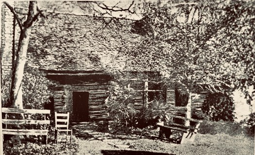
Back at my snowed in camper in Tennessee, I turned back to my search for Cavan-a-Lee, the home Hugh Graham gave to his daughter Connie and her husband William Houston Patterson. The house was built on the other half of the Roddye property, across Warrensburg Road from Hayslope.

Doing some old newspaper searches, I noticed that the name “Cavan-a-Lee” slowly vanished in the 1940s, and yet there was no reference to anything having happened to the house. One of W.H. and Connie’s sons, Hugh Graham Patterson (H.G.), had married Lucy Nenney – the great niece of the original Hugh Graham’s wife, Catherine Nenney – and they lived at the Nenney House, now the Longstreet Museum.

H.G.’s sister Louise and her husband Horace Miller apparently lived at Cavan-a-Lee until their deaths in 1942 and 1940 – which is when the name vanishes from the record. Mr & Mrs J.D. Easterly, who owned Modern Cleaners in Morristown, bought the home in 1952 and began an extensive restoration project, redoing the six-room house, “with its beamed ceiling, pine-paneled den, and wide-open fireplace accessible from both the living room and the kitchen,” Morristown Gazette columnist Connie Helms wrote in her “Connie’s Corner” column.

Connie’s Corner, April 20, 1953. Morristown Gazette-Mail.

And on April 20, 1953, the house burned to the ground, taking with it all the restoration and numerous antiques already put in place by the Easterlys.

But where was this house? Turns out, Connie’s Corner tells us, almost – “at Hayslope near the E.M. Lane residence,” which is over by the railroad. There were a cluster of three houses there at the time – the Lanes owned a sizable chunk of the property there, which leads me to believe they bought it either from WH and Connie Patterson or from their estate.

It also seems to be an unlikely location for Cavan-a-Lee. Maybe. Another possible location – near Hayslope and the Lane home – is past Hayslope and up on the hill above the road. That property was also part of the Lane estate, though, and is supposedly the location of a home that burned mysteriously on a Halloween night – certainly not April 1953. The ruins of that home were still visible when I was a kid

Interestingly, I couldn’t find another mention of the Cavan-a-Lee fire other than in the Connie’s Corner column – or even a mention in the Morristown papers of the Halloween night fire, so …

So where was it? “At Hayslope,” Connie Helms said … could it have been standing just across the road from Hayslope? The property between the road and Fall Creek in front of Hayslope was not part of the Lane estate. Part of it belonged to Hugh Rogan – the part where the spring is. So I suppose it’s possible that part of that property belonged to the Patterson estate, and that’s where Cavan-a-Lee stood. Seems a little trip to the courthouse to find out where the Easterlys owned land is in order.

Such a shame that Cavan-a-Lee’s history seems to have been lost even before the house itself was lost, although the Easterlys were clearly making an effort to bring it back to its former glory.

Let’s see … what else. Well, while trying (again) to figure out Cassie’s property and searching for Cavan-a-Lee, I got to wondering if some of the houses out past Hayslope, on Hayslope’s side, might have been some of the cottages connected with the resort – specifically the house just on the other side of the city’s strip of property. That’ll require some deed research, I imagine. Sure would like to figure out where Cassie’s property was though. She apparently had a house on it, where her father was when he died.

And speaking of Theo Rogan, I re-read his obituary last week and saw something I’d missed. Apparently, Theo kept a daily diary from the time he was 7 years old until a few days before he died. Am I on a search for that? Why, yes, I am. And that search has already uncovered Theo writing a little history of his family, said to be excerpted from some larger “Reminisces,” which I think we can be quite certain came from his diaries.

Of rocks, dirt, drones, and Civil War Trails

So last week I was up in Russellville to find Hayslope’s septic tank. Need to know where it is so we don’t do something like pour a concrete slab on top of it.

Found it. As you may or may not know, there’s a lot of really big rocks there, especially in the back of the house, and naturally one of those really big rocks was mistaken for the hidden septic tank at first, but that was the only errant dig. The tank was further away from the house than I expected, which is great, slightly off to the side and not directly behind it too.

This was where the big rock was, not the tank, and the photo doesn’t do the dirt justice. Nice frost on the ground though. My feet were freezing.

Big surprise: It’s a homemade concrete tank that has now been in the ground for, oh, about 85 years, still doing its job. The lid had no access hatch, and the septic guys said they could try to put one in, but they’d likely just crush it. Their recommendation was to let it be unless and until it starts backing up, then replace it.

The other surprise was just how rich and dark the dirt was. There was no sign of clay for a good two feet, which I guess is what happens when a piece of earth sits there for a really long time without being overused. Smelled really nice too, you know, like rich, dark dirt.

I’ll Fly Away, Oh Lord, I’ll Fly Away

I took a drone up with me, intending to map the property and create a 3D model of it, which I did. You didn’t think it would be that simple, though, did you? Of course not! I did two flights – the first a close up of the immediate area around the house. No problems there, although I should have extended it just a little further to the back, so I guess I’ll do that one again.

The other … the entire 28 acres. This one I set to fly a little higher so as not to run into trees around the woods at the back of the property, which are on a hill. And that worked like a charm. No crashing. I knew ahead of time this would take two batteries, and it was time for the drone to fly back to me so I could swap them out.

A bit of the 3D model

Except that’s not what happened. The drone dropped its connection with the controller and took off north, in the opposite direction from where I was. We’ll not talk about what I said and did for the next little while, but the little monster was half way to Grainger County by the time I (somehow) convinced it to turn around.

The relief when the numbers telling me how far away the thing was started dropping … and it came back, I swapped out the battery, and finished the flight. Don’t think my heart slowed down for a couple more hours though.

Happy Trails to You

And we’re moving ahead on getting placed on the Civil War Trails, too. That’s a multi-state network of sites related to the war with brochures for all the states so you can follow the trails through each state and then some specific topics like “Lee’s Retreat,” “Road to Freedom,” and “Gettysburg.”

At each site, there’s a sign with details about that specific spot, so I’m working on the text for our sign now. I think I show’d y’all a preliminary text a few months ago, and I’ll let you see what I end up with too. I’m taking a close look at the text on the signs at the Longstreet Museum and Bethesda Cemetery so what we say can be part of the story of our whole area.

It’s also gonna bring one of the first obvious signs of work at the house, because CWT requires a small, safe parking area for visitors. I already know where it’s going, so just searching out the folks to create it right now.

And also

I wandered around the yard a bit, spotting the fish pond that Chris Hurley dug out a few years back. It uses some of the giant rocks and will be very nice to get working again. Near where the septic tank was, I found an unusual outline of … something. No idea what. A flower bed, perhaps? And beneath a tangle of brush, the remnants of a brick wall that could be what once was a grill. At least that, I’m sure, came from the 30s. It’s sure gonna be interesting to clear out the brush around the edges and find out what’s under there.

The fish pond, the outline (with the brick wall behind), and that rock.

And then there’s that rock with the lines on it. Maybe it was used as a hard surface for some axe work?

The next trip up will be in about a month, I suspect. I’ll be marking the parking area at that point and trying to find a storage unit somewhere … but they all seem full.

The waiting game

That’s where we are now … waiting waiting waiting.

Can you tell anything about this room? I sure can’t.

The IRS has gotten up to May 20 in assigning 501(c)(3) applications, so we’re still about two months out getting ours assigned. I couldn’t get the interior photos I needed to start the application for the National Register of Historic Places, so that’s on hold until I can – possibly not until the tenants are gone at the end of the year.

We’re also waiting – and this is a terrific thing to be waiting for – for Dr Carroll Van West of the Tennessee Civil War National Heritage Area to pull his team together and come up for an assessment of the property and recommendations for rehab and reconstruction work. The TCWNHA gets federal money to provide these type of assessments in the heritage area, which covers the entire state of Tennessee, so to say I’m excited about this is a grand understatement. Dr West is a professor at Middle Tennessee State University where he’s the director of the Center for Historic Preservation AND he’s the Tennessee State Historian. He tells me he visited Hayslope once before, many years ago, so it’s a bit of an exciting thing all the way around. More to come on this!

“the home of Mrs James Roddye.” Courtesy of the Tennessee State Library and Archives.

And what do I do while I’m waiting? More and more research, of course. I’ve learned that the old photo of the house before the clapboard – used in the Garden Study Club of Nashville’s 1934 “History of Homes and Gardens in Tennessee” – is in the collection at the state archives, where it’s titled something akin to the “the home of Mrs James Roddye.” That’s an interesting title … if it refers to Mrs Col James Roddye, then she died in 1825 and I SERIOUSLY don’t think the photo dates from then. But does it mean that the house belonged to another James Roddye? Our James had a son James, but our James left the house to Thomas and William, and Thomas lived in it while his mother went to Rhea County, where the son James lived and where she died. Thomas died in 1844, and I’d assumed the house went to his oldest son, also named Thomas. But did it go to his second son James? If that’s the case … it throws into question the story about Hugh Graham buying the house in 1853 to give to Theo and Maria Louisa, who we know didn’t live in it at least until 1862, when Theo came back from Texas. What if the Hugh Graham story is just wrong, and James A Roddy, son of Thomas, inherited the house? He died in 1877, and the photo could very well have happened after that. Theo’s family was living in Jefferson County District 15 in the 1870 census – Witt’s Foundry – and in Russellville, Hamblen County (which was formed in 1870) in the 1880 census. We shall see, I reckon.*

Anyway, what else am I doing? Thinking about what the property can be. I do want to live in it, of course, but I’d also like to find a way to share it, in the tradition of the Roddyes and the Rogans. In that vein, I’m building a library! Books about the area and its history, and who knows what else. If you’d like a look at what I’ve collected so far, it’s right here … and growing.

And finally, I’m thinking about adding the house to the Civil War Trails, which is a pretty cool system of markers of Civil War sites. The Longstreet Museum and Bethesda Church & Cemetery are already on that system, so it makes perfect sense to add Hayslope. So, while I’m doing all this waiting, I started working on the text for the Trails sign. I’ll include it here – let me know what you think:

Hayslope

“Hundreds are without blankets or shoes”

Gen. Lafayette McLaws, headquartered in the home you see before you, wrote his wife before even arriving here in late 1863 that “many of my command are without tents,” shoes, or blankets, and that “the ration is not sufficient, and many are sick.”

After failing to take Fort Sanders in Knoxville, shivering Confederate soldiers camped in the fields around the house in all directions throughout the winter of 1863-1864, as sleet and snow pelted them and temperatures dropped below zero. When winter ended, these weary men followed Longstreet into Virginia and on to Appomattox.

Blaming McLaws for the loss at Knoxville, Gen Longstreet relieved him of command, although the order was countered in Richmond, and McLaws eventually survived a court martial.

Both Union and Confederate troops stayed here over the course of the war, but it was this final winter that left its mark on both civilians and fighters.

Pull quote:

“Out of 300 men in the 13th Regiment, only 32 are reported today as having shoes. The balance have been going barefoot over the frozen ground and a great many were without shoes during the campaign of the last two months. I have seen them marching on the frozen ground with their feet bleeding at every step.”

-December 31, 1863. Sgt William H. Hill, 13th Mississippi Regiment, McLaws’ Division

Sidebar:

This house was built in 1785 by King’s Mountain veteran James Roddye, a signer to Tennessee’s first constitution. He operated his home as the Tavern with the Red Door here on the Kentucky Road. Many a traveler from North Carolina to Kentucky stopped here for a hot meal, a swig of Roddye’s whiskey distilled on the property, and a good night’s sleep.

Alternate sidebar:

Both Federal and Confederate troops occupied the area throughout the war. Longstreet’s chief of staff, Moxley Sorrel, noted: “When the Confederates came on the ground, then was the time for acts of brutality against their Union neighbors …. Burnings, hangings, whippings were common — all acts of private vengeance and retaliation. When the turn came and the Unionists were in authority, Confederate sympathizers were made to suffer in the same way, and so it went on throughout the bloody strife.”

Soldiery artifacts at the Museum of Appalachia

I’m hoping to include the photo of the house, if I can obtain a copy from the state archives, possibly a photo of some soldiery artifacts found on the property, and a couple others I’m considering.

Whachyall think?


back of the photo of the house. Courtesy of the Tennessee State Library and Archives.

So … shortly after writing this post, the Tennessee State Archives emailed me with a scan of the original photo of the house – and the back of it. And it doesn’t say “home of Mrs James Roddye” at all. It says “home of Col James Roddye” and that the photo came from Mrs John Trotwood Moore, the great-great-great granddaughter of the colonel (if he really was a colonel) and his first wife (Catherine Chase). Anyway, I’ve tracked her lineage back to James’ son Jesse, who was one of the sons who moved to Rhea County. Now I have some leads to see if I can’t find more old photos of the house … that particular one has to be pretty old. And also, I’m gonna get a high quality print of the photo from the archives!

scan of the original print. Courtesy of the Tennessee State Library and Archives.