A new family has taken the helm of Hayslope. I knew this would be hard – restoring this old place has been my dream for a long time – but it just became increasingly clear that I lacked the wherewithal to actually finish the job. The search began to find someone who could.
With the able help of Daniel Shew, a Bristol realtor who specializes in historic properties, we found that person.
Josh Callahan, with his wife Taylor and family are the new owners of Hayslope. Josh is from Big Stone Gap and has an education degree (specialty in history, although his job is insurance man). He doesn’t know the ins and outs of Hamblen County’s history – yet – but he has a deep and abiding interest. After the signing last week, I took him up to the Longstreet Museum and introduced him to a few of the guys who will be happy to help him learn as much as he wants, as well as offer introductions to more folks.
The Callahans
Josh, who currently lives over on Cherokee Lake, is still letting plans percolate through right now and isn’t completely settled on what he wants to do. He is definitely behind restoring the original cabin portion of the house that James Roddye built and perhaps the other half too. He is undecided if he wants to live in in the historic house or restore it and build a living residence elsewhere on the property.
He also wants so get the old spring functional again and is looking at what needs to be done to that bottom land to make that happen.
The web site is gonna stay up for now. Josh says he’d like for it to track his progress, the way I used it to track mine, so we’ll be sorting that out as we go. There’s also just too much information about the property and all the people involved here to let it go!
So, from the Roddyes to the Nenneys, the Grahams then the Rogans and the Thomasons, Hayslope continues its 240 year journey with the Callahans. Please welcome them to Russellville if you see them about!
But wait! There’s one more thing …
I should take this opportunity to let you know that it’s absolutely confirmed that James Roddye came to what became known as Tennessee from Pennsylvania. I was 99 percent sure of it, but while I was handing over the mountain of books and other things I’ve collected over the years to Josh, I took another look at the diary of the two Moravian brothers who traveled through our area in the late 1790s and spent a night at the colonel’s.
The brothers came from North Carolina and were headed to the Nashville area. They wrote about their journey and the people they met along the way, including the night they spent at Roddye’s home. I can’t say how I missed this the first time, but this time I saw that Roddye himself told the brothers he came south from Pennsylvania and that he was familiar with their church because he had attended their congregation in Lititz, Pennsylvania, on several occasions.
Lititz is near Lancaster, which is the area I felt all but certain the Roddyes landed when they came from Ulster decades earlier.
The Lititz Moravian Church. This building was restored in 1958 after a fire destroyed the 1787 structure.
And there we have it. James Roddye came from Pennsylvania, settling in the Watauga area before the Revolutionary War. After his service at King’s Mountain, he had land grants in the Bent Creek area, while his father in law, George Russell, had the land grants in what would eventually become Russellville.
I’ve never seen any indication that Russell actually lived on the property – he appeared to live across the Holston River in what would eventually be Grainger County. Roddye began building his house there on Fall Creek in about 1785 and bought the property from Russell.
The Roddyes lived there until the colonel’s son, Thomas, used the property as collateral for the debt he owed his father in law, Patrick Nenney. After Patrick’s death, his executors – his widow and son-in-law Hugh Graham – called the debt in. Thomas hightailed it off to Georgia a few years later and disappeared. His wife, the former Lydia Nenney, came back with her children.
The property belonged to the Nenneys until about the mid 1850s, when Graham bought it. He left the old Roddye property to two of his daughters in his will, and Louisa, married to Theophilus Rogan, got the part of the property with Roddye’s homestead. The Rogans owned the property until Theo’s death in 1904 and Louisa’s in 1910, when the property was divvied into five parts for their children. Ellen Stephens got the 28 acres with the house, although her sister Cassie lived in it until her death in 1932.
Ellen sold the house and its acres to Briscoe and Escoe Thomason in 1937, and Escoe sold his half to his brother about 10 years later. My dad inherited it from Briscoe, his dad, and I inherited from my dad.
It’s been a long time, and much has happened since I last wrote on these pages. The news I have to tell you now is not good, for me anyway, but it will be good for the house and for the legacy of the Roddyes, Nennys, and Rogans.
Hayslope is for sale.
My heart breaks. This decision has been a long time coming. I’ve probably waited too long to make it, but the truth is I lack the wherewithal to finish the project. I’m happy with the work we did complete – including this summer’s inclusion with Civil War Trails – but I’ve finally come to the correct conclusion that Hayslope won’t be returned to anything like its former glory with me at the helm.
This has been my dream since I was a very little girl., and for a while I believed I could make it happen and actually live there, on site, to showcase the tremendous history of the property and of little Russellville. But alas, it’s not to be.
I won’t bore you with my personal tribulations, other than to say this has been quite a year, and the result of it is this decision. I’ve contracted with Daniel Shew, a realtor in Bristol who specializes in old houses. Hayslope may be a bit of a challenge, but it’s certainly right up his alley, and he’s excited to help us find a buyer who will finish the project – and that will be part of the contract with the seller.
There are so many people to thank for the invaluable help they’ve given over these past few years. I’ve debated whether to even try to list them all, for fear I’d forget someone. Dakota Carmichael, whose knowledge of history and genuine love it inspired me in so many ways. Megan Gray, who let me believe it could be done and guided me to do what we did to correctly and with joy. Sabrina Cagle, who let me hang out upstairs and talked with me about our family long into the night. Chris Hurley, Leslie Williams, and Rhonda Reno, the remaining board members who had my back. Dr Dockter at the East Tennessee Historical Society. Mike Beck and Kelly Ford at the Longstreet Museum. Sally Baker at the Crockett Tavern. The entire Hamblen County Genealogical Society. Rogan and Roddye relatives I stalked on Facebook who shared photos and memories of their families. Drew Gruber of Civil War Trails. Anne Ross at the Morristown Chamber of Commerce. Councilperson Kay Senter. Contractor Thomas Fraser. All of you who’ve followed the progress (or lack thereof lately) as we’ve pushed forward.
I wanted this to turn out so differently. It’s my love of Hayslope and its history, though, that leads me to this painful decision. The house will live on, just without me.
OK, last time I gave you a rundown of the ownership of the Roddye property through the years (specifically narrowing down to the 28 acres where the house now sits). Today, we’ll talk about the founding Russellville.
Our little town was named either for George Russell, the colonel’s friend and father-in-law, or for the entire Russell family, and it’s pretty certain that James Roddye was behind the choice of that name. Roddye married Russell’s daughter, Lydia, either just before or just after King’s Mountain, while both were still living in the Watauga settlements. After King’s Mountain, Russell and Roddye were among the men who came looking for land further west and landed in our area.
Roddye’s land grants are all along Bent Creek, which puts him in what’s now Whitesburg, and Russell’s were along Fall Creek, which plants him in what we call Russellville (I have seen one or two mentions of “Russelltown” in some really old documents, but apparently it was the ville that won out).
I’m not altogether certain that George Russell ever lived here. He was living across the river in what’s now Grainger County (German Creek, to be specific) fairly early on, and the documentation we have says the Roddye built his house in 1783, which is the same year that both men applied for their land grants.
One of Russell’s surveys, showing Fall Creek
Now, applying for the grants and actually having them officially recorded in the deed book sometimes took quite some time. The reasons for that involve the time it takes to send a surveyor out to do the official survey, come back and record it, which takes people to handwrite them into the deed book, along with copies of the deed and survey for the new “owners.” And there were a lot of them. The Europeans were grabbing as much Cherokee land as they could and making a fortune selling it to other Europeans, all the while heading out to force the Cherokee further and further away from their newly grabbed land. It takes a lot of time, all on horseback or foot.
So Russell’s Fall Creek grants, applied for in what was then Greene County, North Carolina, moved next (and very briefly, since it didn’t make it to actual state-ness) to the State of Franklin. The deeds were finally written into the deed book in 1787, still in the not-really-real Franklin and also North Carolina at the same time. At about that time, William Armstrong’s land around his Stoney Point and some acreage around it, including Roddye’s and Russell’s, ended up in the newly formed Hawkins County, North Carolina. So the deeds are transferred to the new county seat, Rogersville, and the following year – 1788 – the idea of Franklin bit the dust forever.
Meanwhile, Russell has sold the Fall Creek properties to Roddye for 300 pounds. That deed is recorded in Rogersville in 1790, and at about that time, North Carolina cedes the territory west of the Appalachians to the US government, and it become the Territory South of the Ohio River. Two years later, Jefferson County is formed, and our area falls into that county. Four years after that, the territory south of the Ohio is admitted to the union as the 16th state, Tennessee.
Whew. Once Tennessee is a state, Roddye got really busy buying and selling. He even briefly disappears from his Jefferson County lands in the early 1800s. I once thought he may have gone down to Rhea County, where his son Jesse had gone, but it appears that instead he went to Claiborne County, where he operated a ferry over the Powell River on the Kentucky Road as well as a tavern. He was there for a few years before returning to Russellville, where he owned most of what eventually became “downtown.”
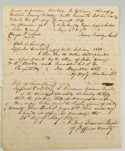
1810 deed from Roddye giving Deaderick the rights to run a mill race over his property
In 1810, he gave William H. Deaderick, a Hawkins County doctor, a deed to build a dam on Fall Creek and a mill race to cross Roddye’s property for a mill the good doctor built on his own property, adjacent to Roddye’s. It must have been around this time that Roddye and Deaderick began talking about the idea of an actual town.
In about 1819, the two men created a plan for said town. I’ve not found that plan yet, but I’m still searching. I know there was one because it’s mentioned in the official act to create the town of Russellville, which we’ll get to shortly.
Meanwhile, from about 1819 forward, Roddye and Deaderick are involved in selling land along what they call the Cross Roads Street – what we’ve known as Russellville Pike, Main Street, or just the old road. Deeds show that there were 18 “town lots” created along Cross Roads Street, each 1/4 acre. Some of them have alleys between them. Here’s a very rough sketch of those lots (not to scale!!!):
Somewhere I wrote down the size of the lots, but just now I can’t find it. They were about 60 feet by 160, but please don’t quote me on that. Fall Creek ran probably through lots 1 and 3 on the east side of town, which were owned by Roddye. Deaderick owned 2, 5, and 6, so the 1810 deed gave Deaderick the right to run a mill race across Roddye’s property to reach his mill, probably on lot 5 or 6. I say that because Deaderick later sold lots 5 and 6 to Patrick Nenney, and the mill race is mentioned in those deeds – which also leads me to believe that the Nenney House/Longstreet Museum probably sits on the back side of those two lots (the old town lots of Russellville got further chopped up in the 1910s when the Russellville Land Company bought up most of the Nenney property and sold it with a new layout).
Anyway, there’s a lot of buying and selling of the town lots during this time, and Roddye’s son Thomas continues that after his father’s death in 1822. Since Roddye and Deaderick had created this plan, I have to believe that they were working to get the Tennessee legislature to officially create the town of Russellville. Maybe there’s even correspondence about this somewhere. But we do know that in 1826, the legislature finally did just that, establishing the town (citing Deaderick and Roddye as the ones who laid out the plan) and naming “commissioners,” who may or may not have ever met, but they certainly had the right to do so.
The act creating the town of Russellville (Chapter CLXXXVII)
The commissioners were William Felts, who owned a tavern probably on lot 3 (which later became the Riggs Tavern), James Phagan, James L. Neal, John Cox, and Joseph Austin. Another maybe, but maybe somewhere there’s correspondence about these commissioners and what they may or may not have done in their official capacity.
Oh – there’s also the handwritten bill creating the town of Russellville. You’ll see on the third page the notations about all the readings in the Tennessee House and Senate before it’s officially passed, signed by the governor (William Carroll), and recorded in The Acts of Tennessee:
The original bill establishing the town of Russellville
Obviously, Russellville ended up being just a little village, with no commissioners. I have not yet found anything in the Acts of Tennessee disestablishing the town, so I can’t say how that may have come about. It was a bustling little town for a while, though, right up through the establishment of Hamblen County in 1870 and into the 20th century.
Well, I kinda feel like I hit the historical document jackpot anyway. I’ve been using Family Search’s experimental AI search of online documents, and it’s kinda working out – although I can say that I can read cursive marginally better than the AI can. Still, the machine function gets me close to where I want to be in the scanned documents, then all I have to do is page through and find all manner of surprising things.
It’s a little tedious, but also fun. Today, Imma give you the biggest news first: I found the document in which George Russell, the colonel’s father in law, sells his Russellville property to James Roddye. We knew something like that happened, since Russell’s land grants were on Fall Creek and Roddye’s were mostly on Bent Creek, but had not found the proof of it. Now we have. But we found it where we hadn’t looked before – in Hawkins County, not Greene as we’d supposed. Here’s how it went down.
George Russell’s deed to James Roddye
Russell put in for the property in 1783, around the same time that Roddye put in for his grants on Bent Creek (there is a grant for Roddye from 1780 on the south side of the Holston, which might or might not be in Russellville, but I’ve not sussed out details on that one yet). The 1783 Russell grant is for land on Fall Creek, bordering Donalson’s and Cheek’s lands and definitely corresponds to what we know of the Roddye-Nenney-Graham-Rogan property of the 19th century. Anyway, Russell put in for the property in 1783, the same year that Greene County was carved out of Washington County, then in North Carolina.
The grant wasn’t issued until nearly four years later, in 1787. Now, this is fairly common. It took 11 years for one of Roddye’s grants to be officially issued, and most of them took anywhere from three to eight years. As far as I’ve been able to tell, that has to do with there being a lot of land grants and the time and personnel to do all the recording and surveying. By hand. In duplicate and sometimes triplicate. Not to mention travel times.
And then, of course, there’s the changing political landscape in East Tennessee. By the time Russell’s grant was finally issued, that little corner of Greene County had just become Hawkins County, still in North Carolina. Meanwhile, in between 1783 and 1789, Roddye is selling his properties on Bent Creek (to names like Kilpatrick, Horner, and White that you’d recognize from our area’s history). And it takes time to record all those too.
So over in Hawkins County is the deed transfer from George Russell to James Roddye for the property listed in the 1787 grant. That’s mentioned right in the deed, which was recorded in January 1790, by which time records show Russell living across the river in what would later become Grainger County.
I have no doubt that Roddye built the house on the property, apparently before he officially owned it. Russell was the colonel’s father-in-law, after all, and the two were apparently very close. Roddye served, with Russell’s wife Elizabeth, as Russell’s executor when he died in 1798. Russell, Roddye, Bean, all those guys – they came to our area from the Watauga settlement after King’s Mountain. Bean settled on the north side of the river immediately, and apparently Russell yeeted over there pretty quickly. Roddye stayed on the south side, and, I suspect, saw to it that Russellville took the name of his wife’s family.
Lot-tery
I’ve mentioned before that most of these guys were land speculators, buying and selling and farming and running businesses, and Roddye was no different. As best as I can tell, he owned a large portion of what we know as Russellville – the little village, in particular. The Jefferson County deed book tells us that somewhere around 1820, probably just before, the colonel divided up his property in Russellville proper into lots – at least 22 of them – and began selling them at $50 a pop. These lots appear to start around where Fall Creek crosses what’s now the Andrew Johnson Highway and the old Main Street and move back west from there. That starting point is also where the colonel sold the rights for a mill race to one William H. Deaderick in about 1810, and mention of that mill race shows up frequently in the deeds. That tells me there was a mill right about there before Cain Mill was built a little further north along the creek.
Russellville now. Photo by Dakota Carmichael/The Old History Project
The colonel didn’t sell all his lots. His son Thomas sold several in the late 1820s, around the same time he signed the bulk his father’s property over to Patrick Nenney’s estate to pay for a debt he owed. Patrick was Thomas’s father in law, and he owed this debt at the time of Patrick’s death in 1824 but never paid it. The Nenneys got the property in 1829. At the same time, Thomas was having a fire sale, disposing of properties – including enslaved people – before he split Tennessee to try his hand at gold in Georgia. And before the sheriff of Jefferson County, James Bradford, seized what property he had left in downtown Russellville and sold it on the courthouse steps in Dandridge in 1835 to pay a substantial debt he owed some folks in Baltimore. His debtors bought the whole “lot” of it for $100, and, I’m assuming, made more than that selling it again, but I haven’t gotten that far in the deed book just yet.
What happened to Thomas Roddye is still a mystery. There’s an 1834 JeffCo document that says he is “lately deceased,” but I don’t know how accurate that is. Needham Jarnigan, who travelled with him to Georgia, wrote to Charles P. Nenney (both Roddy and Jarnigan’s brother in law) in 1837 saying that his whereabouts are unknown and that he suspects rumors that he killed himself over the substantial debts he owed, a sizable portion apparently incurred while in Georgia, were true. It was around that time that Thomas’s wife, Lydia, came back to Russellville/Whitesburg.
Charles P. Nenney was by then almost certainly living at what would eventually be known as Hayslope. The executors of Patrick’s will, Hugh Graham and Lucy Bramblette Nenney, Patrick’s widow, signed the property over to him in 1835. He was living there in 1845, when he sold it to Graham. So there you have it – the Nenney ownership was from 1829 to 1845.
Lydia Nenney Roddy, Charles P.’s sister and Thomas’s wife, lived in Whitesburg on property she inherited from her father for the rest of her life, by the way.
The Rogans forward
Graham’s will, written in 1861, designates how his children were to divide his property after his death. As far as the old Roddye property is concerned, the will says for Theo Rogan, Louisa’s husband, and Absalom Kyle, Mary Ann’s husband, to hire surveyors to divide it in half, and then Louisa, “being the youngest,” gets first pick. She picked the half with Roddye’s old home on it
The will gives the property to Mary Ann and Louisa (specifically the daugthers and not their husbands) on January 1, 1862, or Graham’s death, whichever comes first. Graham died in 1865, and we know the Rogans were living at the house in the latter part of the Civil War, but we also now know that the official deed transfer didn’t take place until 1868, likely because of that war.
The Kyles held onto the other half until the 1880s, when their heirs sold it to another Graham sister, Connie, and her husband William Houston Patterson. The Rogans kept the their half until their deaths, Theo in 1904 and Louisa in 1910, when it went to their five surviving children. They divided the property up and drew lots from a hat to see who got what.
The colonel’s property south of Russellville. Dakota Carmichael/The Old History Project
Ellen, the youngest, got the 28 acres with the house. As she was married to a citrus magnate and living in Florida, with no intentions of returning to Tennessee, she told her sister Cassie she could live in the house. Cassie, the oldest Rogan and the only one who never married, sold her own lot, which was down by Sugar Hollow, and moved into the old Roddye place, now called Hayslope by her mother.
The other three children – Griffith, Hugh, and Maggie – eventually sold their portions as well. Griffith and Hugh eventually moved to Florida, near Ellen, and Maggie already lived in Virginia. Cassie lived in the house until she died in 1932, and Ellen sold it to Escoe and Briscoe Thomason – whose family by that time had bought a substantial portion of the colonel’s Russellville “town lots” and sold many of them again — in 1937. Escoe sold his portion of the property to Briscoe about 10 years later.
My dad inherited those 28 acres from his dad, and I inherited from him.
And that, my friends, is the story of James Roddye’s property in Russellville.
… at least here on the website. Those of you who follow Hayslope on Facebook have seen the occasional post there, but I have been remiss at keeping you up to date here. That’s because I generally use posts here to update after I’ve been on site, and I haven’t been since last September.
There’s a good reason for that. I had a nasty little fall and badly injured a leg right after returning from my last visit. It’s healing, albeit quite slowly, but it’s my driving leg and that makes it tough to drive for the length of time it takes to get up there.
But that doesn’t mean nothing’s been happening. The good news is that we’ve passed the point where there’s much that little old us can do ourselves and well into the time when those who actually have the wherewithal to do the heavy work are on it.
Let’s recap
Stuff!
We started this journey cleaning out the house about a year ago, and that was quite the task. So.Much.Stuff. And then more stuff. For a while, I was pretty sure ole Theo Rogan was putting more junk in there every time we left for the night. Eventually, though, all that didn’t belong was out and gone.
And finally, we could actually see what we were working with. And what we were working with was a 238-year-old log cabin that had an addition, built on stick framing, about 15 to 20 years later. And the walls were covered in chestnut boards. The roofline had been altered probably three or four times during the old girl’s lifetime, and there was the infamous addition put on by my uncle Escoe in the late 1930s which included a modern (for then) kitchen and bathroom, and a room upstairs made entirely of cedar.
We had the two open fireplaces on the north side, one downstairs and one upstairs. And the bigger, original fireplace in the original cabin – which had been closed in with a Franklin stove venting out through the chimney. And after a little outside cleanup, it was on those chimneys that the real work commenced.
Fire it up
We brought in the masons to rebuild those fireplaces and chimneys as well as the mystery chimney we found in the “modern” kitchen. Most importantly to me was the original fireplace – I wanted it open again and redone so that it could be used as it originally was, as a cooking fireplace. This was absolutely gonna be the single most expensive thing we did to the house, but to me WORTH IT.
Taking the big chimney all the way to the ground was necessary to get to the inside of it, mostly because the original had been enclosed at some point, I’m guessing pretty early on, likely to match it with the chimney on the addition. That chimney was taken all the way down too, to make sure it was sound once done. Both chimneys were rebuilt with the original brick and lined with a new stainless steel flue – or in the case of the south side chimney, two flues because the upstairs and downstairs chimneys had separate flues. Then, new caps on the top with dampers installed.
The big, southside chimney
Then there was the matter of the mystery chimney in Escoe’s kitchen. It did appear to be made with handmade brick, but we saw no sign of an actual fireplace on that wall (it would have been the back right corner of the original cabin. It stopped in the ceiling of the kitchen, however, and was clearly used to vent whatever cooking appliance was there originally. We had it taken out and rebuilt from the floor in the basement up. Most of it used the original brick that was in what was there, but our masons brought in some extra, period brick from elsewhere for the base, since there wasn’t enough to do that.
Now, to the original fireplace. It’s big, maybe not giant, but pretty big. Dakota and Megan had been certain they saw an arch when peering down behind the mantel. I couldn’t see it, but it sure was there, and uncovering it was something else. We first saw it from outside as the chimney came down. There were the massive log mantel beams, lots of original chinking, and that arch.
And, once we were down that low, it was time to take out the brick and concrete that had enclosed the fireplace from the inside. Once we were at this point, I could get the measurements for the fireplace and order the cooking crane we wanted to use so that the masons could mortar it in when they rebuilt the firebox itself.
That’s when something amazing happened. The guys took the concrete and brick off – it wasn’t as all-pervasive as we feared – and there, still mortared in place, was an iron rod, a pre-crane, iron lug pole used to hang pots over the fire for cooking.
The guys lit a fire in the big fireplace. Lug pole and clay firebacks in place.
A lug pole was typically a piece of green wood secured high up in a chimney so it wouldn’t burn, with a system of hooks and trammels used to hang pots (and raise or lower them as needed) . The lug pole gave way to the crane, which could be swung out and therefore not be quite as dangerous for the cooks. But this, apparently, was a step in between – an iron lug pole that could be put much lower and closer to the fire and not have to be periodically replaced as the wood lug pole would be.
Needless to say, I quickly cancelled the crane order. We wouldn’t be needing it and would use Roddye’s original iron lug pole for cooking.
Further discoveries included the original iron and clay firebacks, which are also back in place in our fireplace. The masons did have to take down the arch in order to rebuild it, using a curved piece of wood to place the bricks back into their arched shape and keep them in place until the mortar dried.
We’re also keeping the mantelpiece. It would have been far more work than we wanted to do to take it off, because of how it was attached to the brickwork, but it’s early 19th or late 18th century, and so original to Mr Roddye.
Onto the land
I never finished my post about my last trip up, in September, onaccounta the aforementioned accident, but the big deal of that trip (aside from seeing the chimney work for myself) was walking the land.
Dakota, Rhonda, and Nori in the woods.
Friends and board members Rhonda and Leslie, joined on that Saturday by Dakota (and all weekend by dog Nori) walked the land, seeing what native plants abound in the hills, and also a quick look at what invasive species we’ll need to dig or pull out.
And that’s because Hayslope wants to cultivate and propagate these native species, along with heirloom varieties of fruits and vegetables we’re all familiar with. It doesn’t look like James Roddye’s orchards have survived the years in any useful format, so we’ll recreate those, and there was plenty else out there to find.
I haven’t talked much about our plans beyond the house, and there’s that whole 28 acres out there. We have no intention of ignoring that treasure! And, oh my, what a treasure it is.
Leslie’s botanical survey, which she said was “a very small beginning,” found passionflower, Dutch white and red clover, sassafras, blue vervain, boneset, goldenrod, poke, sweet violet, lance leaf plantain, mullein, staghorn sumac, great burdock, black stem peppermint and oh so much more. Up in the woods we found some pretty old growth hickory, including shag bark hickory, beech, chestnut, white, and red oak, Eastern red cedar, black walnut, black cherry, and more. Fall Creek was lined with sycamore trees, and tulip poplars (the state tree of Tennessee) popped up in several locations.
The idea here is to create a nursery of native species, another way for Hayslope to present its history and bring that into the present – for the future of us all.
While wandering around out in the fields – including the “swamp” between the spring and the creek (which wasn’t a swamp when I was a kid!) – we did see a few spots on the creek that could do with some clearing. There’s a small lake forming back under the Warrensburg Road bridge and beyond, so we’ll be looking to getting the creek flowing free again. As for the swamp, it’s likely caused, in part, by the creek blockages and in another part by blockages at the spring, which does appear to be bubbling up out of the ground just fine, if not flowing freely to the creek as it should.
What’s next?
Well, next I’ve GOT to get back up there. Soon, I promise …
Meanwhile, we begin work on the interior. Thomas Fraser, our contractor extraordaire, has taken the ceilings off upstairs, exposing the rafters and showing us, for the first time, how the roof really has changed over the years. Escoe’s multi-window dormers, which are prominent on the front and back now, were once just two single-window dormers on the front. One of those is completely gone and the other remains as a weird little closet above the stairs in what we call the Rogan Room.
The cedar room, dismantled.
Thomas has also begun work dismantling Escoe’s addition. That included a careful tear-down of the cedar room, and those boards have been carefully bundled up and put in storage for future use, just as we did the chestnut boards downstairs.
He’s also working to preserve a discovery the masons made when they were taking down the mystery chimney. Thomas opened it up further, but what we found back there were original walnut shingles on the original roof line, preserved beneath the modern roof instead of being torn off.
Annie Kendrick Walker, in her discussion of the Rogans’ 1904 50th wedding anniversary, mentioned the walnut shingles. I never expected to see them, and was planning to find someone who could build a display of what they would have looked like, but now we have the real thing.
Walnut shingles
So next is shoring up the foundation so that when the addition is removed, the back wall doesn’t come crashing down, and so that our new roof can be safely secured. We’ve had the engineer outline what we need to do (pretty much what we knew we needed to do) and are preparing to do that. Most of what needs to happen is beneath the back right side of the house, where Escoe dug a cellar for his wife Etta Mae’s canning. That’s where the worst of the termite damage is (yes, we had some, but it wasn’t nearly as bad as my mom told me it was!), so some beam replacement will be necessary.
That’s the way it is
And now, you’re up to date. The house is standing strong and is visited almost daily by the neighborhood cats, so I’m thinking there won’t be any rodent problems. Just now, as I’m finishing up this post, a new cat wandered by the big chimney. Handsome ginger fluff. At night, the cameras see raccoons and opossums and the occasional dog, and of course, the cats come by at all hours.
One of our illustrious furry visitors. They know all the secrets.
I’ve watched windstorms, rain, and snow through my cameras since I’ve been up last, and gosh I really do miss sitting outside and listening the birds, watching those buzzards and hawks soar overhead.
Typing all this up has just made me want to be there even more.
When I spoke recently at the Hamblen County Genealogical Society, my first slide was about “Things that’s aren’t true.” It was a short list of things I’d heard all my life about Hayslope and the people who lived there – things that research showed me just weren’t quite right.
I get it. Somebody sometime way back when said something, and from that time on it was just accepted as true. And then there’s the game we knew as telephone – how stories change in the telling over and over. Whatever the origin, I quickly learned that there were some things that had been accepted fact that weren’t.
James Roddye wasn’t a Revolutionary War colonel
No, he wasn’t. Now, it does appear that he was called “colonel” for the rest of his life after the war, but Roddye was a private at King’s Mountain, the only official battle of the war he was actually in. I got my first inkling of this in applications for membership in the Daughters of the American Revolution. Roddye indeed fought at King’s Mountain, but in all the applications I’ve seen, he was listed as a private. In some cases, applicants had called him a colonel, only to see DAR officials cross that out and write in “private.”
When the Overmountain men came back to East Tennessee from King’s Mountain, they fought another battle, this one against the Cherokee, at Boyd’s Creek. Roddye commanded troops in that battle – which is not always considered a battle of the Revolutionary War – and may well have been a captain at that time. But he still wasn’t a colonel, and Boyd’s Creek marked the end of his pre-United States military career.
In fact, most of the Overmountain men were never official soldiers. They were militia men who went into battle because their leaders, men like John Sevier and Isaac Shelby, called them to.
So how did Roddye get to be a colonel? Well, that came from the State of Franklin. The men who fought at King’s Mountain wanted to be a state, and not a part of North Carolina across the mountains. The short-lived “state” or “free republic” lasted from 1784 to 1788, and James Roddye, who had lived in Greene County, ended up in the new county of Caswell, on the north side of the Nolichucky River. John Sevier, Franklin’s governor, appointed him lieutenant colonel of the Caswell County militia, serving as second in command to Col. Alexander Outlaw. And from then on, Roddye was known as Col. James Roddye.
Roddye’s land grants did not include what would become Hayslope
We’ve all heard that Roddye built his house on the land grants he got from his service at King’s Mountain. If that’s true, I haven’t found the proof of it. Roddye’s grants were all over in what is now Whitesburg, on Bent Creek, not in what’s now Russellville on Fall Creek. Know who did have land grants on Fall Creek in what would become Russellville? Capt. George Russell, a friend of Roddye’s, fellow King’s Mountain veteran, and Roddye’s father-in-law. And the descriptions of Russell’s property sound just like the property we know to have ended up in Roddye’s hands.
One of Russell’s grants
I’ve not yet found any documentation about the sale of Roddye’s Bent Creek properties or his acquisition of Russell’s Fall Creek property, but I’m still looking. I suspect he bought it from Russell about the time George moved across the river to what’s now Grainger County. The two remained friends for the rest of Russell’s life – Roddye was the executor of his will when he died in 1797.
Russellville was not named for George Russell’s daughter, Lydia, Roddye’s wife
It was named for George Russell. I mean, come on. Common sense would tell you that. The confusion came from poor wording. Something akin to “Roddye married the daughter of George Russell, Lydia, for whom the town was named” became “Roddye married George Russell’s daughter Lydia for whom the town was named” and so on.
But no. Russell was the first of the Overmountain men to settle in what is now Russellville, on Fall Creek, where he reportedly had a mill. Russell strikes me as the kind of guy who just wanted to be left alone, so when more people began moving into Russellville (or Russelltown, as I’ve seen it called a time or two around this time) he bugged out to the other side of the Holston, leaving the town that bears his name to Roddye and those who came after.
Hugh Graham didn’t give Hayslope to his daughter as a wedding present
This one took some serious unpacking. Hugh Graham was a prominent Claiborne County businessman who got his start, with his brother William, as an apprentice with Patrick Nenney. The Grahams later went into business with Nenney, and Hugh Graham in particular grew very very wealthy, with land holdings all over East Tennessee and western Virginia.
He married Catherine Nenney, Patrick Nenney’s daughter, and they had several children, all of them girls except for one. Ultimately, he gave his house – Castle Rock in Tazewell – to his son and other properties to all his daughters and their husbands. The story had been that Graham gave what we know as Hayslope – half the Roddye property, which he bought either from James himself or his son Thomas – to his daughter Louisa when she married Theophilus Rogan in 1853.
Louisa Graham Rogan
There was just one problem. Rogan, an attorney who had worked for Graham, had gone to Texas in the late 1840s to practice law with his brother Leonidas and was still living there when he came back to Tazewell to marry Louisa. Then he and Louisa went back to Texas, where they stayed until Louisa returned to Tennessee in 1860, as the Civil War neared its start, and Theo followed in 1862.
So did he give them the property even though they weren’t going to be living there? Theo and Louisa had intended to stay in Texas, but the war changed those plans.
Graham’s will gave the answer to that, and also opened up more questions. Graham wrote his will in 1861. It was a lengthy and complicated document, with several codicils since he didn’t actually die until 1865. But the disposition of his properties to his son and daughters is very clear.
Graham decreed that “the Rhoddy farm” – which he said he bought from Charles P. Nenney, not a Roddye at all – should be divided between his daughters Mary Ann and her husband Absalom Kyle of Rogersville and Louisa and Theo. He devised an intricate plan for dividing the property equitably into two parts and then said that Louisa, “being the youngest,” should have first choice of which half. And she chose the half that became known as Hayslope. There’s no mention in Graham’s will about a wedding present, and the will further stipulates that the daughters will take possession of the property on January 1, 1862, or Graham’s death, whichever comes first.
Hugh Graham
But wait a minute. Graham bought the “Rhoddy” property from Charles P. Nenney, Patrick’s son and Graham’s brother-in-law? The Nenneys once owned the property? This was news to me, but I soon found the answer to that as well.
Here’s some background: James Roddye, who died in 1822, left his Russellville property to his son Thomas, stipulating that his wife Lydia should have use of it for the rest of her life. This probably worked out well for her, since Thomas was frequently traveling on business, although what kind of business we don’t know. Anyway, Thomas got married in January 1824, to Lydia Nenney, another of Patrick’s daughters. And then just three months later, Patrick Nenney died.
Several years earlier, I’d seen a document sold at auction in Knoxville that said it was an “indenture” between Thomas Roddye and John Donalson, another Overmountain man from our area. I kept copies of the document, but never read it. And because I never read it, I didn’t see the names of Hugh Graham and Lucy Nenney, Patrick’s wife. Nor did I see that the document was actually a promissory note of sorts from Thomas Roddye to the estate of Patrick Nenney.
The following year after Thomas’s marriage and Patrick Nenney’s death, Lydia Roddye, while visiting some of her children who lived in Rhea County, Tennessee, died and was buried there. And later that year, Thomas Roddye signed a document that said he owed the estate of Patrick Nenney $2,120 and that he promised to pay it. If he didn’t, the document said, John Donalson was authorized to sell his father’s property on the courthouse steps and give the proceeds to the Nenney estate, whose executors were Hugh Graham and Lucy Nenney, now Patrick’s widow. Four years later – in the document that was sold in Knoxville in 2013 – the parties acknowledged the earlier agreement, noted that Thomas Roddye had failed to pay his debt, and agreed that he would give his father’s property to the Nenney estate to satisfy it.
And that’s how the Nenneys came to own James Roddye’s property.
Exactly how Hugh Graham got it, we don’t yet know. He said in his will he bought it from Charles P. Nenney, who died in 1857, so we can safely assume it was before that. We don’t know if the property went to Charles in 1829 or if perhaps his mother took control of it at that time, in which case Charles P. would have gotten it when she died in 1853. All we can say for sure is that Hugh Graham bought Roddye’s land sometime between 1829 and 1857 and that the Nenneys, perhaps ever so briefly, once owned it.
Slave cabins were not still standing behind the house into the 1960s
I didn’t hear that until I was a little older. I saw those cottages, back when I was very young, and was told then that they were part of the resort. Later on, after they were torn down, someone suggested they had been slave cabins, which also made sense to me.
Turns out that what I was originally told was closer to the truth.
After Theo Rogan died in 1904, followed by Louisa in 1910, their children divided up the Hayslope property and drew from a hat to see who got what. Ellen Rogan Stephens, married to a citrus magnate and living in Florida, drew the house and its 28 acres. Hugh drew the property directly south of Ellen, Griffin the property behind Hugh’s, then Maggie, who was living in Virginia, the next parcel south, and Cassie the property closest to Sugar Hollow.
Ellen, who had no intention of returning to Tennessee, suggested that Cassie, who was unmarried, live in the old homeplace. She did that, selling her piece of the property. Maggie, in the same place as Ellen not intending to return to live in Tennessee, also sold hers, as did Hugh and Griffin, both of them moving to Florida near Ellen.
A chimney from one of Killiecrankie’s cottages.
Hugh sold his parcel to a cousin, Robert Patterson. Robert promply built a house and three cottages just across the old Kentucky Road from Hayslope, the road having long since become the drive into Hayslope. He called his house “Killiecrankie,” after a Scottish battle his Graham kin had participated in. The house was for the summer use of himself and his wife, Maude Hooper Patterson, her sister Ruth and her husband Robert Blair. The cottages were for the use of his mother-in-law, Maude Philpot Hooper, and other family members and friends. In the winter, they all returned to Selma, Alabama, where the Hoopers resided.
This lasted for decades. Robert Blair and Robert Patterson both died in the 1940s, and the sisters, Ruth and Maude, continued their summers in East Tennessee. Maude Patterson died in the 1950s, and Ruth Blair kept coming until she, too, died, in 1966. At that point, the city of Morristown ended up with that narrow strip of property and tore everything down.
Those three cottages were part of Killiecrankie, not slave cabins from the Roddye era.
We do think we can perhaps locate those slave cabins, along with other structures from older eras, on the property.
And no, that’s not James Roddye either
James Roddye’s signature on Tennessee’s first constitution
So that’s it. Things we thought were true but weren’t. Then there’s the picture in the slide – no one ever thought that was James Roddye; I just used it as an illustration. We’ve not found a portrait of Our Man James anywhere so far, although there are photographs of two of his daughters – Polly and Sednah. James probably did dress like that though.
Oh, and there’s also one famous historian who says that James’s brother William signed Tennessee’s first constitution. I figure he just got confused, because it very clearly says “Jas. Roddye” on that document.
After threatening to do it for a while, I did it. I wrote the book about Hayslope. It’s small, 61 pages, with a few pictures, but it tells you everything we know and don’t know about the house, the land, and the people who’ve lived there.
And it’s ready for purchase. “A Brief History of Hayslope and Its People” is $13, including shipping, and available here on the website. So if you’d like a copy, now’s the time. Shipping begins mid-week.
And thanks to all of you for supporting this project of love in all the ways you have!
Over on Facebook, a post appeared this morning in a group I belong to with a newspaper clipping from February 24, 1812. The newspaper writer wrote about an earthquake felt near Cheek’s Crossroads on the 7th of that month. I recognized that date – it was the last “big” quake in a series of tremblers called the New Madrid earthquakes – the most powerful earthquakes to strike east of the Rockies in recorded history.
The first hit on December 16, 1811, and was followed by two powerful aftershocks. Another strong quake hit on January 23, 1812, and the last big one – there were plenty of aftershocks – rattled the area on February 7. That one destroyed the Missouri town of New Madrid, caused the Mississippi River to briefly flow backwards, and formed Reelfoot Lake.
“An Old Friend” wrote in the Knoxville Gazette that morning that “the shock of an Earth-quake was felt in this neighborhood much more severe than either of the lately preceding ones.” He wrote that he’d walked by his creek in the morning and noticed that it had overflowed, but not because his mill pond had broken.
“I can explain the phenomenon in no other way than supposing that a surplus quantity of water was thrown over the breast of the dam by the oscillation of the earth during the shock,” he wrote.
Further, An Old Friend said that springs belonging to two of his neighbors – which previously flowed with “the purest streams and whose bottoms have never exhibited any appearance but that of a mirror” – were “sending forth water angry looking muddy and totally unfit for the common purposes of life.”
The Great Comet of 1811, sketched by Royal Navy officer William Henry Smyth
The writer also references the Great Comet of 1811 (C/1811 F1), which was visible to the naked eye for 260 days and at its brightest in October of that year. Prior to Hale-Bopp in 1997, it had the longest recorded time of visibility. The comet was visible during the quakes. With an amused tone, he notes that the comet, the quakes, and the Battle of the Wabash (Tippecanoe in November 1811) had brought out “whimsical ideas … [that] inspired the minds of the mass of our less intelligent, though not upon that account less respectable, brethren,” although he did note that “we cannot help thinking that the machinations & devastations of the sons of lawless power and ambition in the older hemisphere & the calamities produced & still threatened by the common & mysterious power and agents of nature in the new, combine to render the present era gloomy and portentious.”
I actually wrote about New Madrid (and I was eviscerated online because of the reference to the “big one” in California – knowing full well that no one actually believes that will happen. I mentioned it because people were again talking about it) when I worked for CNN. Here’s what I said about it in 2005:
“[The New Madrid fault line is] a 120-mile-long system of three to five faults stretching from 40 miles northwest of Memphis to southern Illinois, near Cairo.
“‘The system is capable of producing a quake near 4.0 magnitude every three years,’ said Gary Patterson, a geologist and information services director for the Center for Earthquake and Research Information in Memphis, Tennessee. ‘And they’ll cause minimal damage.’
“But New Madrid already has spawned four earthquakes this year of similar size, along with nearly 100 smaller quakes. Patterson said such activity may or may not be the precursor to a much larger quake.
“The recent activity is an anomaly, he said.
“‘It’s unusual, and we don’t have any reason to believe there is increased risk,’ Patterson said. ‘But any time you have this kind of activity in an area that has a 25 [percent] to 40 percent chance of a 6.0 or greater in the next 50 years, it will draw attention.’
“And the region is ill-prepared for a strong quake, he added.
“Under pressure
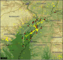
The New Madrid seismic zone
“Scientists know little about how the New Madrid seismic zone works, but in the early 19th century, it was the source of the most violent series of earthquakes known in North American history.
“The zone, named for the town of New Madrid, Missouri, is hundreds of miles from a tectonic plate boundary, which Patterson said defies the logic of coastal earthquake science.
“‘Plate tectonic theory can account for large quakes on the edges of plate boundaries, but plate boundary theory assumes a rigid continental plate,’ he said. ‘Madrid is in the middle of a continental plate, not on the boundaries.’
“Three large quakes happened in the winter of 1811-1812, and strong rumbles hit several times until near the end of the 19th century.
“These quakes were felt keenly over more than 2 million square miles — people in Boston, Massachusetts, felt one or more of the three main quakes, the first of which struck in three shocks on the morning of December 16, 1811.
Fissure, now filled with sand, formed by the New Madrid quakes. Photo taken in 1904.
“Two more large shocks struck the area — on January 23, 1812, and the largest and most devastating of all hit February 7, 1812, destroying the town of New Madrid.
“By contrast, the 1906 earthquake in San Francisco, California, was felt over 60,000 square miles.
“Patterson said the incredible distance the quakes reached was largely due to the cold, solid rocks ‘that make this continent float,’ a different environment from the plate boundaries on the coast.
“‘On the boundaries, the rock is hot, molten and broken up,’ he said. The solid rock carries the movement farther from the epicenter.
“Earthquake researcher Otto Nuttli estimated 200 moderate to large earthquakes on the New Madrid fault between December 16, 1811, and March 15, 1812, and about 1,800 earthquakes of slightly lesser strength.
“The stronger quakes lifted parts of the land high or dropped them down, and drew the Mississippi’s waters in and threw them back far over the river banks. In some areas, the upheaval beneath the surface was so violent that it caused the mighty river to flow backward.
Woodcut by Henry Howe, 1854, showing destroyed cabin after the New Madrid quakes.
“Whole islands in the river — and entire towns — disappeared.
“The strongest quake in the area since 1895 was a magnitude 5.5 in 1968. New Madrid is ‘a sleeping giant we don’t understand very well,’ Patterson said.”
New Madrid is different because it’s not along the border of a tectonic plate, where most significant earthquakes occur. It’s in the middle of North America, and quite a few seismologists think it’s got more big quakes in it.
Me, I’m just wondering who “An Old Friend” was. And I’m wondering what the Roddyes thought about all the shaking going on.
I just spent nearly a week up in Tennessee, most of it snowed in, sitting in a camper in Morristown, drinking hot chocolate and watching Welsh crime dramas on TV. I did accomplish a few things, though.
Into the orchard area.
And no, the tenants aren’t yet gone. That’s … annoying. It’s going to happen, though. Meanwhile …
I met up with Kenny, who took care of the yard at my dad’s place after his death, and he’s ready to do the same at Hayslope, once the tenants are out and the grass starts growing again.
I also planted some colorful little flags across the lower part of the yard, marking out where the CWT parking area will go, and met with Jerry, who’ll be grading that and dumping in the gravel for it. He’ll have to come back and look at it again when the snow’s gone to price it out, but we’re getting set up there too.
Flags. They were still there in the snow.
While wandering around the yard, I spotted two things I hadn’t noticed before. One, the gate posts at the driveway are for split rails, and two, both of the stone markers at the Kentucky Road entrance are still standing – over the summer I couldn’t get close enough to see the south one because of all the overgrowth.
Both stone markers.
Got the many boxes of books and other items out of my meditation room and into a storage space in Morristown, which was MUCH easier said than done. Turns out storage spaces, particularly climate controlled ones, are in short supply in East Tennessee. The one I finally found is small, but will do for now, and at least when I’m meditating, I’m no longer hidden behind stacks of boxes!
With all the snow – very pretty, by the way – I had a lot of inside time and used some of it (when not watching Welsh crime dramas) to do a little research. First, I tried (again) to map out Cassie Rogan’s property lines, but I’m still stumped by the reference to “old Arnott Road,” which intersects with the Russellville Road (now Warrensburg) – at least I was.
I was looking for a set of hex keys in my basement when I came across a book I’d forgotten I had, called “Historical Echoes of Hamblen County,” signed to my mom by its author, Connie Maloney Haun, who taught school in Morristown for 30 years. It’s gonna take some doing to go through this book – it’s not the best organized. But in the front was a map I’d never before seen – and that map marked “Arnott Road” as what we know now as Warrensburg Road between Silver City Road and Little Mountain Road. At that point, the road becomes Fall Creek Road on this map (which is one of the many names I knew as a child – Warrensburg Road was never one of those). So, FOUND IT. I’ll be trying again to mark out Cassie’s property soon.
Arnott Road, found at last!
A couple other interesting notes on this map, which has no date or provenance – it appears to mark what we now call Sugar Hollow Road as “Old Russellville-Warrensburg Road.” Jarrell Road used to be “Herald Road” (or was there just a mispronunciation/misspelling?) What’s now Beacon Hill Road was “Catherine Nenney Road,” and the spot where the church is was actually a community called Nenney. And a long time question has been answered for me – Silver City was at the intersection of Little Mountain Road and Silver City Road.
The map is specifically of Hamblen County, and clearly after 1942 since it shows Cherokee Lake – or very close to it. Enka Highway is marked on the map, Slop Creek Road is Slop Branch Road, and Interstate 81 – not completed in Tennessee until 1975 – is marked. Now, plans for I81 were made in the 50s, so …. and the highway is marked on the map, in parentheses, “FCA.” Don’t know what that means.
Back at my snowed in camper in Tennessee, I turned back to my search for Cavan-a-Lee, the home Hugh Graham gave to his daughter Connie and her husband William Houston Patterson. The house was built on the other half of the Roddye property, across Warrensburg Road from Hayslope.
Doing some old newspaper searches, I noticed that the name “Cavan-a-Lee” slowly vanished in the 1940s, and yet there was no reference to anything having happened to the house. One of W.H. and Connie’s sons, Hugh Graham Patterson (H.G.), had married Lucy Nenney – the great niece of the original Hugh Graham’s wife, Catherine Nenney – and they lived at the Nenney House, now the Longstreet Museum.
H.G.’s sister Louise and her husband Horace Miller apparently lived at Cavan-a-Lee until their deaths in 1942 and 1940 – which is when the name vanishes from the record. Mr & Mrs J.D. Easterly, who owned Modern Cleaners in Morristown, bought the home in 1952 and began an extensive restoration project, redoing the six-room house, “with its beamed ceiling, pine-paneled den, and wide-open fireplace accessible from both the living room and the kitchen,” Morristown Gazette columnist Connie Helms wrote in her “Connie’s Corner” column.
Connie’s Corner, April 20, 1953. Morristown Gazette-Mail.
And on April 20, 1953, the house burned to the ground, taking with it all the restoration and numerous antiques already put in place by the Easterlys.
But where was this house? Turns out, Connie’s Corner tells us, almost – “at Hayslope near the E.M. Lane residence,” which is over by the railroad. There were a cluster of three houses there at the time – the Lanes owned a sizable chunk of the property there, which leads me to believe they bought it either from WH and Connie Patterson or from their estate.
It also seems to be an unlikely location for Cavan-a-Lee. Maybe. Another possible location – near Hayslope and the Lane home – is past Hayslope and up on the hill above the road. That property was also part of the Lane estate, though, and is supposedly the location of a home that burned mysteriously on a Halloween night – certainly not April 1953. The ruins of that home were still visible when I was a kid
Interestingly, I couldn’t find another mention of the Cavan-a-Lee fire other than in the Connie’s Corner column – or even a mention in the Morristown papers of the Halloween night fire, so …
So where was it? “At Hayslope,” Connie Helms said … could it have been standing just across the road from Hayslope? The property between the road and Fall Creek in front of Hayslope was not part of the Lane estate. Part of it belonged to Hugh Rogan – the part where the spring is. So I suppose it’s possible that part of that property belonged to the Patterson estate, and that’s where Cavan-a-Lee stood. Seems a little trip to the courthouse to find out where the Easterlys owned land is in order.
Such a shame that Cavan-a-Lee’s history seems to have been lost even before the house itself was lost, although the Easterlys were clearly making an effort to bring it back to its former glory.
Let’s see … what else. Well, while trying (again) to figure out Cassie’s property and searching for Cavan-a-Lee, I got to wondering if some of the houses out past Hayslope, on Hayslope’s side, might have been some of the cottages connected with the resort – specifically the house just on the other side of the city’s strip of property. That’ll require some deed research, I imagine. Sure would like to figure out where Cassie’s property was though. She apparently had a house on it, where her father was when he died.
And speaking of Theo Rogan, I re-read his obituary last week and saw something I’d missed. Apparently, Theo kept a daily diary from the time he was 7 years old until a few days before he died. Am I on a search for that? Why, yes, I am. And that search has already uncovered Theo writing a little history of his family, said to be excerpted from some larger “Reminisces,” which I think we can be quite certain came from his diaries.
So last week I was up in Russellville to find Hayslope’s septic tank. Need to know where it is so we don’t do something like pour a concrete slab on top of it.
Found it. As you may or may not know, there’s a lot of really big rocks there, especially in the back of the house, and naturally one of those really big rocks was mistaken for the hidden septic tank at first, but that was the only errant dig. The tank was further away from the house than I expected, which is great, slightly off to the side and not directly behind it too.
This was where the big rock was, not the tank, and the photo doesn’t do the dirt justice. Nice frost on the ground though. My feet were freezing.
Big surprise: It’s a homemade concrete tank that has now been in the ground for, oh, about 85 years, still doing its job. The lid had no access hatch, and the septic guys said they could try to put one in, but they’d likely just crush it. Their recommendation was to let it be unless and until it starts backing up, then replace it.
The other surprise was just how rich and dark the dirt was. There was no sign of clay for a good two feet, which I guess is what happens when a piece of earth sits there for a really long time without being overused. Smelled really nice too, you know, like rich, dark dirt.
I’ll Fly Away, Oh Lord, I’ll Fly Away
I took a drone up with me, intending to map the property and create a 3D model of it, which I did. You didn’t think it would be that simple, though, did you? Of course not! I did two flights – the first a close up of the immediate area around the house. No problems there, although I should have extended it just a little further to the back, so I guess I’ll do that one again.
The other … the entire 28 acres. This one I set to fly a little higher so as not to run into trees around the woods at the back of the property, which are on a hill. And that worked like a charm. No crashing. I knew ahead of time this would take two batteries, and it was time for the drone to fly back to me so I could swap them out.
A bit of the 3D model
Except that’s not what happened. The drone dropped its connection with the controller and took off north, in the opposite direction from where I was. We’ll not talk about what I said and did for the next little while, but the little monster was half way to Grainger County by the time I (somehow) convinced it to turn around.
The relief when the numbers telling me how far away the thing was started dropping … and it came back, I swapped out the battery, and finished the flight. Don’t think my heart slowed down for a couple more hours though.
Happy Trails to You
And we’re moving ahead on getting placed on the Civil War Trails, too. That’s a multi-state network of sites related to the war with brochures for all the states so you can follow the trails through each state and then some specific topics like “Lee’s Retreat,” “Road to Freedom,” and “Gettysburg.”
At each site, there’s a sign with details about that specific spot, so I’m working on the text for our sign now. I think I show’d y’all a preliminary text a few months ago, and I’ll let you see what I end up with too. I’m taking a close look at the text on the signs at the Longstreet Museum and Bethesda Cemetery so what we say can be part of the story of our whole area.
It’s also gonna bring one of the first obvious signs of work at the house, because CWT requires a small, safe parking area for visitors. I already know where it’s going, so just searching out the folks to create it right now.
And also
I wandered around the yard a bit, spotting the fish pond that Chris Hurley dug out a few years back. It uses some of the giant rocks and will be very nice to get working again. Near where the septic tank was, I found an unusual outline of … something. No idea what. A flower bed, perhaps? And beneath a tangle of brush, the remnants of a brick wall that could be what once was a grill. At least that, I’m sure, came from the 30s. It’s sure gonna be interesting to clear out the brush around the edges and find out what’s under there.
The fish pond, the outline (with the brick wall behind), and that rock.
And then there’s that rock with the lines on it. Maybe it was used as a hard surface for some axe work?
The next trip up will be in about a month, I suspect. I’ll be marking the parking area at that point and trying to find a storage unit somewhere … but they all seem full.